Storm Babet end date for Newcastle announced as country hit by floods and strong winds


An end date for Storm Babet has been confirmed by the Met Office, who announced a red weather warning for part of the UK earlier this week.
Newcastle is bracing itself for wild winds and a rise in rainfall following the Met’s announcement of a yellow weather warning in the region. Both today (Friday, October 20) and tomorrow (Saturday, October 21) are listed as yellow warnings.
Advertisement
Hide AdAdvertisement
Hide AdFast-flowing waters and some damage to homes and businesses are to be expected according to the Met, who say the storm should fully pass by Monday.
Until then, residents in Newcastle were warned to take precautions over wind and rain warnings formally announced by the weather body earlier this week. They say delays are likely and some bus services and train travel could be delayed or cancelled.
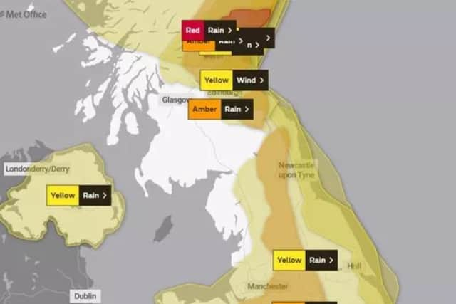
A statement from the Met Office read: “Storm Babet will push intense rainfall and gusty winds into northern areas this evening. The winds strengthen overnight across much of Scotland and the rain will become persistent here. Turning calmer and drier for a time in the south.
“A further area of very strong easterly winds will affect some western parts of northern England with gusts of 60-70 mph possible during Friday afternoon and evening, easing overnight. Winds will ease from generally from the south through Saturday.”
Advertisement
Hide AdAdvertisement
Hide AdNo warnings are in place for Sunday but wet conditions could be on the cards for those in the North East.
The outlook for Tuesday, following the hopeful conclusion of Storm Babet, does not look hopeful of sunny skies or warmer weather though. A statement from The Met Office reads: “Staying largely unsettled through this period with showers or longer spells of rain, but overall a gradual improvement in conditions is expected with time. Feeling fresher than of late.
“Conditions may improve from the west later. The following couple of days will likely see further showers or longer spells of rain in places, perhaps becoming focused more towards western and southern areas. Daytime temperatures remaining close to average, however with mild nights for many.”
November holds worse news still for those hoping for a break from wilder weather forecasts. The Met said: “Rainfall may be higher than average in the south and southwest at first, however as the period progresses a more average precipitation distribution may establish.”
Comment Guidelines
National World encourages reader discussion on our stories. User feedback, insights and back-and-forth exchanges add a rich layer of context to reporting. Please review our Community Guidelines before commenting.